Related Images and Videos : View All
Axial Base V17

The new instrumented science pod, all bright and shiney, is installed on the Shallow Profiler Mooring at Axial Base. Credit: UW/OOI-NSF/WHOI, V16.

A school of small fish greeted the ROV ROPOS during our first visit to this ~ 600 ft deep platform since it was installed in 2014. Credit: NSF-OOI/UW/ISS; Dive R1832; V15.
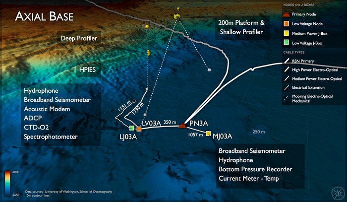
Location: 46.1082ºN 129.6182ºW Water Depth: 2650-2654 meters
In contrast to the margin setting of the Slope Base Site (PN1A), the Axial Base Site (PN3A) at the foot of Axial Seamount is far from the continental shelf (>350 km offshore) and hence represents an open-ocean or pelagic site in the continuum of observing scales represented in the OOI's cabled system. Here, large-scale currents including the North Pacific Current, the subpolar gyre and the northern end of the California Current interact. These currents transport heat, salt, oxygen, and biota, all of which are crucial to the region's ecosystem. However, their variability arises from forcing as varied as tides and winds to interannual (El Niño) to decadal (Pacific Decadal Oscillation) timescales. Examples of relevant science questions explored here include: 1) How, and how strongly do tidal currents break down into turbulence, and what are the feedbacks on the large scale current system? Internal tides are common vertical motions formed by tidal currents flowing past bottom features such as Axial Seamount and the base of continental margins with steep topography; 2) What is the impact of long- and short-term forcing changes on the structure and transport of the large-scale current system? What are their effects on the ecosystem? Together with the mooring at Ocean Station Papa, these processes can be studied with observing platforms in the water column at these two sites.
