Related Images and Videos
Related Stories

VISIONS '14 Instrumen
The numerous instruments listed below are scheduled for installation during VISI ...
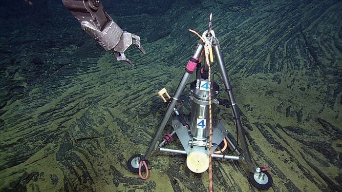
Bottom Pressure and Tilt Meter V14

A bottom pressure tilt instrument is installed at the Eastern Caldera Site on the summit of Axial Seamount. Image Credit: VISIONS'13, NSF-OOI/UW/CSSF; Dive R1617; V13

Deployment of the Bottom Pressure and Tilt meter.
The Bottom Pressure and Tilt Meter (BOPT) is a custom instrument developed by Bill Chadwick at NOAA PMEL in Newport, Oregon The BOPT measures the inflation and deflation of the seafloor at the summit of Axial Seamount using a precision pressure sensor that enables detection of the seafloor's rise and fall (i.e., "breathing") as magma (molten rock) moves in and out of the underlying magma chamber. A very precise tilt meter that measures in micro-radians records the "tilting" of the seafloor as it deforms in response to melt migration.
During VISIONS '14, a bottom pressure tilt instrument has been installed at the International District 2 Site (MJ03D) and at the Easter Caldera Site (MJ03E): one awaits installation at the Central Caldera Site (MJ03F). All three instruments are now streaming data to shore.
The pressure sensor is a Paroscientific Digiquartz pressure transducer and the tilt meter is supplied by Applied Geomechanics (LILY)*
Bottom pressure and tilt meter Overview
