- Visions18
- Visions17
- Visions16
- Visions15
- Visions14
- Construction
- Visions13
- Visions12
- Visions11
-
Enlighten
- As Enlighten '10 Ends
- Exploring an Active Caldera
- Life in the Extreme
- Dive J2-516
- Transforming the ROV Jason
- Weather: Sunday August 15, 2010 ...
- International District to ASHES ...
- A Day Full of Vents and Sunshin ...
- Students at Sea
- Captain's Weather Report
- Weathering a Bit of a Blow
- Details at ASHES
- First Jason Dive at Axial Seamo ...
- David's Spheres
- Newport to Axial Volcano
- Port Call, Newport, Oregon
- Final Science Day Leg 1
- Nice Weather
- Finding a Passion
- Meter-Scale Imaging
- Bubbles from the Seafloor
- Documenting Seep Sites
- Social and Scientific
- Nested Surveys
- Kinship Aboard the Thompson
- Exploring Gary's Bad Hang with ...
August 2010
July 2010

Related Images and Videos : View All
Exploring Gary's Bad Hang with Jason and Sentry
Sunday, August 01, 2010
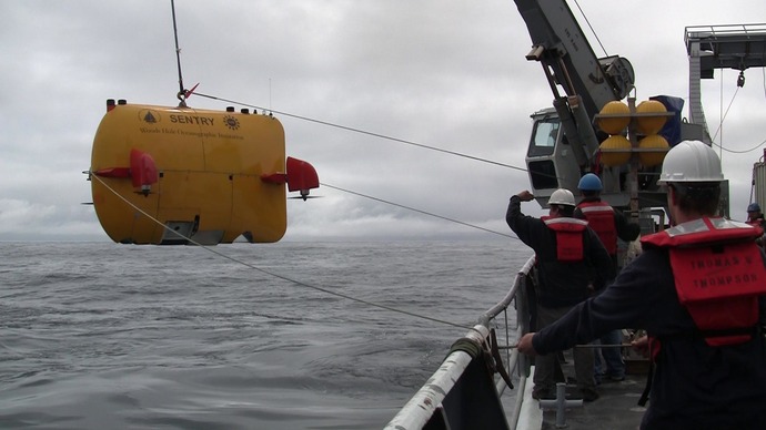

Dana controlling the winch during lowering of Sentry for beginning of Mission 69.

Snails and tracks at Gary's Bad Hang.
Following recovery of Jason, during the very early hours of the morning on August 1, the R/V Thompson transited ~ 9 km due south from Southern Hydrate Ridge and then turned southeast to a site called Gary's Bad Hang. During this transit, a 3.5 kHz sonar (sub-bottom) survey and EM300 bathymetric survey were conducted to characterize bottom structures and topography. In addition, a gravity core was taken ~ 3 km south of Southern Hydrate Ridge to determine the sediment characteristics for cable burial.
Gary's Hang is a candidate location for Primary Node PN1C on the cabled observatory and a survey in this area is necessary to determine if it is appropriate for cable burial, node placement, and the deployment of a variety of sensors and a mooring. This area was chosen as a potential site because it is an area near where fisherman have frequently, in the past, hung up their trawl nets on the bottom and therefore they avoid this area.
Sentry went into the water in the morning, followed by Jason in the afternoon. Both vehicles will continue to map this site at ~ 600- to 400-m water depth until 2100-2400 hrs tonight. Upon recovery of the vehicles, the Thompson will transit back to Southern Hydrate Ridge for additional mapping and imaging.