Related Stories
The Cabled Component
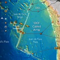
The fiber-optic cables of the Cabled Array, the cabled component of the NSF Ocea ...
Observatories
We must understand the oceans to optimize the benefits and mitigate the hazards o ...
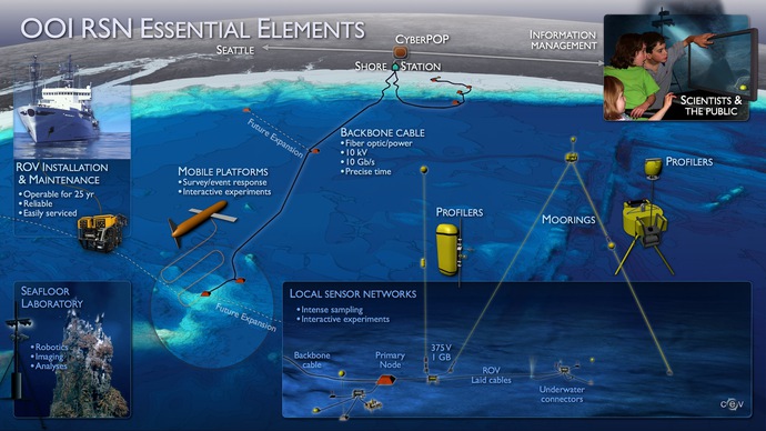
The OOI RSN Cable Sys
The telecommunications industry has a long history of connecting continents, coun ...
Future Expansion of the OOI Cabled Network
Significant expansion capabilities exist to serve future science needs and technological advances
High-frequency radar systems could significantly increase our ability to predict and respond to large storms that sweep onto the Oregon and Washington coasts.

This talk presented the unique opportunities of integrating the existing Integrated Ocean Observing System (IOOS) technologies with the capabilities of OOI RSN and the resulting significant enhancement to IOOS HF Radar coverage along the Oregon and Washington coastlines.
OCEANS' 09 Presentation and paper authors: Jack Harlan, P. Michael Kosro, Pete Barletto
Technical paper here.
A critical design feature of the OOI regional cable network, or Regional Scale Nodes (RSN), infrastructure is the capability for future expansion that will serve growing science needs and technological advances over the 25- to 30-year lifespan of the network. The numerous design scenarios for the RSN were developed from documents contributed by principal investigators and input from science community meetings and workshops. The initial installation design is driven by fiscal constraints.
Future community dialogues among scientists, the public, and educators will help shape expansion of this novel high-power and high-bandwidth infrastructure that brings ocean sciences in real-time to a global community via the Internet.
Examples of areas where significance future opportunities exist include expansion of the following:
- Cabled infrastructure to include a deep-water node and cabling of moorings off of Grays Harbor, Washington. This enhancement allows “mirroring” of the OOI cabled Regional and Coastal Scale nodes west of Newport, Oregon. Expansion of Grays Harbor components will provide information key to understanding seismic activity in the Cascadia Subduction Zone and will significantly enhance early warning systems for seismicity. If the uncabled moorings planned for installation at the Grays Harbor site were converted to cabled moorings, the power and bandwidth would enhance mooring capabilities and data transmission.
- Cable and installation of a major seismic network and a mooring at the Blanco Transform Fault. This transform fault is representative of one of three major tectonic plate boundaries and is an area where magnitude 5 to 6 earthquakes occur. In addition, instrumenting this transform fault would allow investigation of deformation processes in these important zones, as well as studies of the scales over which earthquakes impact fluid flow in the ocean crust, and of the release of gases and associated microbial material.
- High power and bandwidth full water-column moorings on all major nodes on the OOI RSN. This coverage would allow important enhancement of the tsunami warning system off Washington and Oregon, study of hypoxia events and ocean acidification offshore, highe- resolution thermal, chemical, and biological measurements important to understanding the impacts of El Niño, La Niña, and Pacific Decadal Oscillation events on marine life, and the impacts of climate change in the NE Pacific.
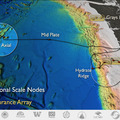
- Node functionality and sensor arrays at the Mid Plate node that include a seismic array, a full water-column mooring, and a tsunami warning system. This is an important offshore site for examining the manner in which stress in the oceanic crust is transferred far away from mid-ocean ridge spreading centers. It is a site key to examining the chemical, biological, and physical processes associated with basin-scale currents that operate far offshore, and is an important location for early measurement of tsunamis offshore.
- Meteorological components that could include high-frequency radar systems pointed shoreward, and arrays of atmospheric sensors to better monitor wind, currents, carbon dioxide exchange between the ocean and atmosphere, and precipitation. Such arrays could significantly increase our ability to predict and respond to large storms that sweep onto the Oregon and Washington coasts.
In concert, these additions would serve a significant and broad science community and provide important contributions to storm, tsunami, earthquake monitoring and response capabilities, and enable significant advances in understanding climate change in the NE Pacific and weather patterns that affect a significant portion of the United States.
