- Visions18
- Visions17
- Visions16
- Visions15
- Visions14
- Construction
- Visions13
- Visions12
- Visions11
-
Enlighten
- As Enlighten '10 Ends
- Exploring an Active Caldera
- Life in the Extreme
- Dive J2-516
- Transforming the ROV Jason
- Weather: Sunday August 15, 2010 ...
- International District to ASHES ...
- A Day Full of Vents and Sunshin ...
- Students at Sea
- Captain's Weather Report
- Weathering a Bit of a Blow
- Details at ASHES
- First Jason Dive at Axial Seamo ...
- David's Spheres
- Newport to Axial Volcano
- Port Call, Newport, Oregon
- Final Science Day Leg 1
- Nice Weather
- Finding a Passion
- Meter-Scale Imaging
- Bubbles from the Seafloor
- Documenting Seep Sites
- Social and Scientific
- Nested Surveys
- Kinship Aboard the Thompson
- Exploring Gary's Bad Hang with ...
August 2010
July 2010

Related Images and Videos
Grays Canyon Survey
Friday, July 30, 2010

Schematic diagram of the mooring for the proposed 500 m Endurance Array site off the coast of Grays Harbor, WA. More information on the mooring can be found here.

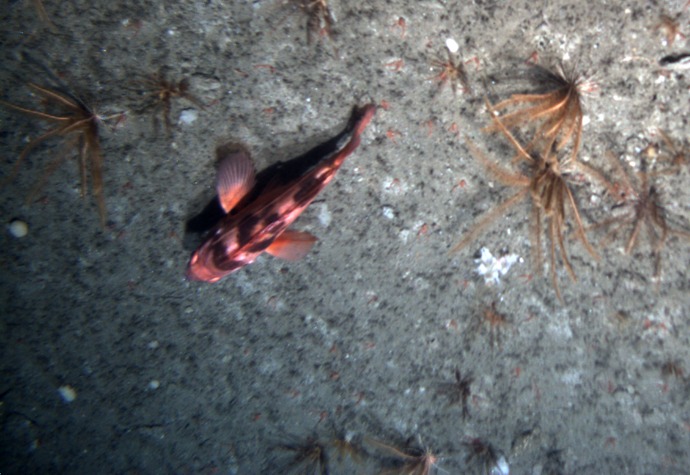
Flatfish on bottom during Jason dive 507 at the potential site for the 500 m moorings.
The coastal margin west of Grays Harbor, Washington, will host three uncabled mooring sites as part of the Coastal Scale Nodes (CSN) component of the Ocean Observatories Initiative (OOI). This area is strongly influenced by fresh water issuing from the Strait of Juan de Fuca and from the Columbia River. Data from the mooring and glider arrays will be used to examine the dynamics of coastal upwelling, river-influenced shelf ecosystems, the impacts of ocean acidification, and El Niño and La Niña events within this highly dynamic system.
On Thursday, we deployed the robotic vehicle Sentry on a mission that successfully mapped a 2x2 km patch of the seafloor that we are considering for the permanent Endurance Array moorings. The candidate site, located on the North side of Grays Canyon, will contain two moorings, pictured here, with instruments to measure winds and sea surface conditions, the properties of the ocean water column, and conditions at the seafloor. While Sentry completed the mapping survey, the remotely operated tethered vehicle Jason dove to the seafloor and crossed the area giving us a view of the sediments and life on the seafloor.