-
Visions18
- Research Cruise? Me?
- Scooping Up Zooplankton From Th ...
- Farther and Deeper We Go
- Leg 3 Short but Sweet and Rewar ...
- Port Call and Leg 3 Begins
- A Very Successful First Two Leg ...
- With Gratitude
- Diving in Extreme Environments
- Crazy Busy and Alighting the De ...
- Leg 1 Down-Onward We Go
August 2018
July 2018
June 2018

- Visions17
- Visions16
- Visions15
- Visions14
- Construction
- Visions13
- Visions12
- Visions11
- Enlighten
Related Images and Videos
Monitoring heat output at ASHES
Thursday, August 02, 2018
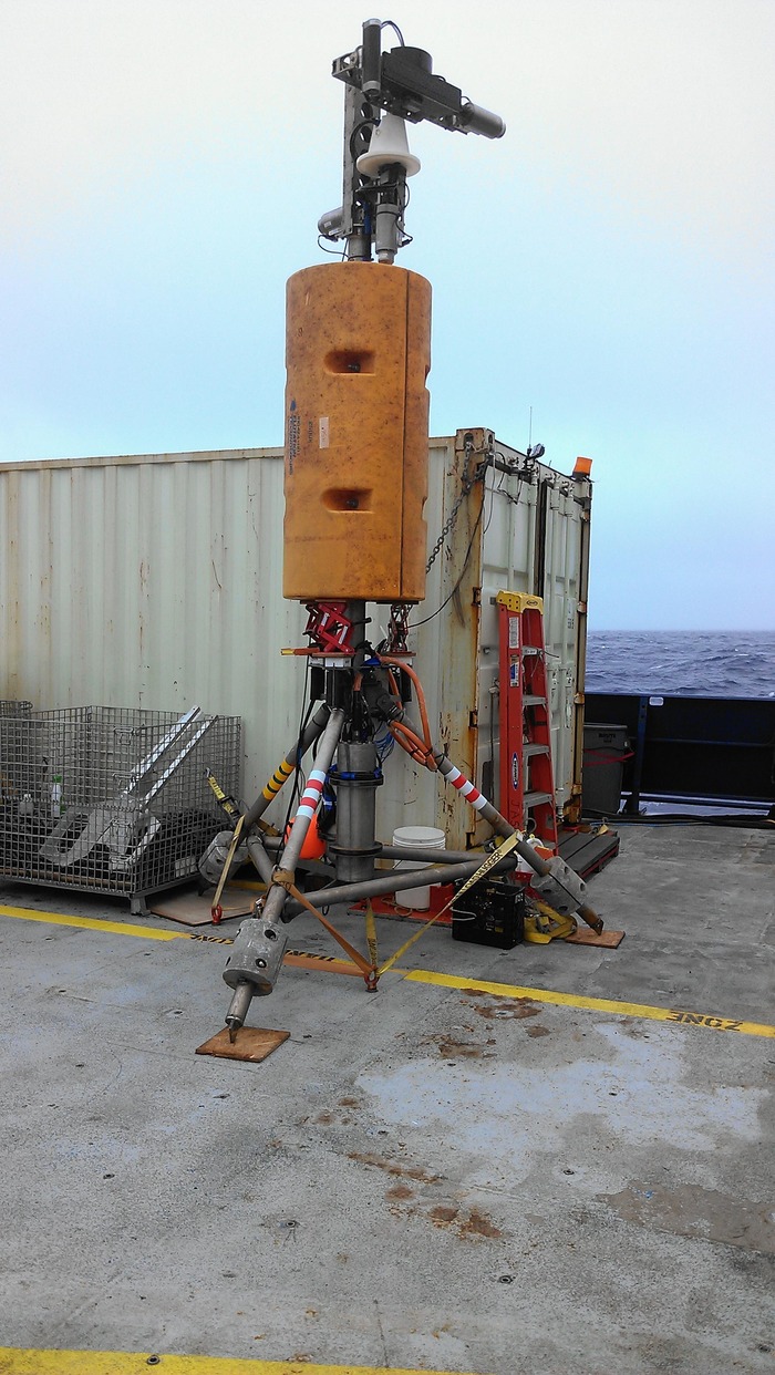

A diagram of the COVIS instrument indicating its major components.

The COVIS instrument is positioned on the seafloor to measure heat output from both chimneys (Mushroom) and diffuse hydrothermal fluids on the seafloor.
A guest blog by Karen Bemis, Research Associate at Rutgers University
Over twenty years ago, I was invited to join a team of geologists, acousticians (physicists who study sound), and engineers and help develop instrumentation that can measure the heat content in hot springs on underwater volcanoes. To a geologist, the hot springs (technically referred to as hydrothermal vents) in the caldera of Axial Volcano indicate the presence of an active volcano (that is, magma – molten rock -- is present deep underneath it). Measuring the heat from hot springs helps understanding how these systems work and the impact of underwater volcanos on the chemistry and heat of the ocean over time.
Over these twenty years, I’ve had the opportunity to work with a large team on a variety of sonar systems and platforms. This work has led to the development of a sonar system designed specifically to monitor hot springs on the seafloor and send its data back through a high-speed and high-power cable to shore. The Cabled Observatory Vent Imaging Sonar, known as COVIS, detects and measures the rate at which heat is transferred from the volcano’s magma chamber into the ocean and the spatial distribution of these hot springs. COVIS uses a commercial multi-beam sonar mounted on a large tripod to detect moving hot (or turbulent) fluids.
COVIS emits sound which is scattered by particles and rapid turbulent changes in temperature. The insturment records the amount of sound that is scattered back towards it and the time the sound took to travel out and back. While each ping of sound covers only a fan-shaped plane, mechanical rotators control the orientation of the fan. As a result, COVIS can determine the amount of backscattered sound from every point within a 50 m x 50 m x 50 m volume, creating an image of plumes rising from hot springs within that region of seafloor. Detailed waveform information is combined with the observed plume geometry to infer vertical variations in rise speed and the overall heat transferred. COVIS also operates in an alternate mode which produces a map of hot spring incidence on the seafloor over a 50 m x 50 m area.
COVIS spent 2010 to 2015 at a site farther north called the Main Endeavour Field. During that time about fours years of plume images, heat content, and hot spring location maps were collected. We learned that the vent we were watching was very stable over that time period. COVIS was recovered in 2015 and refurbished to go out again. COVIS is going to the ASHES site in the caldera of Axial Volcano and will connect to the Cabled Array there.
After it is installed at ASHES, COVIS will survey its surroundings – some what like sonars used to get bathymetry, only COVIS looks more horizontally and we process the data to detect fluid motion as well as solid surfaces. Once the initial survey is done, COVIS will scan the water column and the seafloor roughly every three hours to estimate the location and heat output of the hot springs. Each set of scans that is sent back to shore estimates the location and vertical velocity of plumes rising above high temperature vents called smokers (in this case more white or grey than black) and the distribution of lower temperature vents. We plan to estimate the heat content of both the high and low temperature vents.