Related Stories
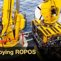
ROV ROPOS Deployment
Julie Ann Koehlinger (VISIONS '13, Leg 2) created this video as her student proj ...
ROPOS Dive Map for RS
J. Ryan Rembert (VISIONS '13, Leg 3) created this interactive map as his student ...

Fredrik Ryden
Fredrik Ryden is a PhD Candidate in Electrical Engineering at University of ...
Fredrik Ryden's blog
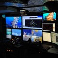
Sitting in the ROV control room is quite a different experience compared to watch ...
ROV Dives in 3D
by Fredrik Ryden

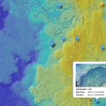
Fredrik Ryden created a prototype 3D visualization of ROPOS dives for his student project. This image shows 15 dives simultaneously on Axial Caldera's bathymetry. The black lines are the RSN cable routes extending from Primary Node PN3B (on the lower right of the image).
3D Visualization of ROV Dives
This video demonstrates a 3D visualization of ROV operations on Axial Seamount's caldera during VISIONS '13. The software provides a framework for visualization of ROV dives and bathymetry, and can also include underwater infrastructure such as cables. The software can be used to visualize actual dives in real-time as well as recorded dives at a faster speed. This type of software could potentially be used by an external audience and ROV operators to get a better spatial understanding of the work environment, especially in the planning stage.
(VISIONS '13, Leg 3)
