Southern Hydrate Ridge V17

The digital still camera (CAMDSB103) sits atop a small, heavily sedimented rampart in front of the actively venting methane seep called Einstein's Grotto at the summit of Southern Hydrate Ridge. Photo credit: NSF-OOI/UW/CSSF; Dive R1767; V14.

Clams at Southern Hydrate Ridge host symbiotic microbes. This "colony" is perched at the ledge above a site known as Einstein's Grotto, which in 2013 was actively venting. Photo credit: NSF-OOI/UW/CSSF; Dive R1750; V14.
Location: 44.6ºN 125.1ºW Water Depth: 780-771 meters
The Southern Hydrate Ridge study site (~10 km north of Primary Node PN1B) hosts abundant deposits of frozen methane (methane hydrates) that are buried beneath and exposed on the seafloor. The deposits vent methane-rich fluids and bubbles that escape through seeps on the seafloor. Dense and fascinating communities of microbes and animals are fueled by these escaping gases. Methane is a powerful greenhouse gas and, therefore, quantifying the flux of methane from the seafloor into the hydrosphere is critical to understanding carbon-cycle dynamics and the impacts of global warming on methane release.
Southern Hydrate Ridge is an important observatory site to define the temporal evolution of methane hydrate systems in response to seismic events. It is also an important area to quantify material fluxes from the seafloor and the impacts of methane release on overlying ocean chemistry. It provides an excellent opportunity to understand biogeochemical coupling associated with gas hydrate formation and destruction.
The real-time and interactive capabilities of the cabled observatory are critical to studying gas-hydrate systems because many of the key processes may occur over short time scales. Events such as bubble plume formation, the creation of collapse zones, and increased seepage in response to earthquakes will require adaptive response and sampling capabilities that include full-resolution sampling by upward-looking sonars, fluid and gas sampling, long-term duration collection of plume and seep imagery from cameras, and in situ manipulation of chemical sensors, which, coupled with flow meters, provide estimates of transient and more stable chemical flux.
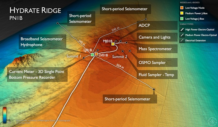
During the UW-Cabled Array-OOI-NSF VISIONS'14 Expedition all infrastructure at this site was fully installed and became operational with live, real-time streaming of data to shore with data available through the OOI Data Portal. The VISIONS'15 Cabled Array expedition was the first Operations and Maintenance cruise - all instruments are now operating at this site. Data from the short-period and broadband seismometers are accessible through IRIS.
