Related Stories
The VISIONS'11 Expedi
The Visions '11 research cruise will take place on the University of Washing ...
The Ocean Observatories Initiative
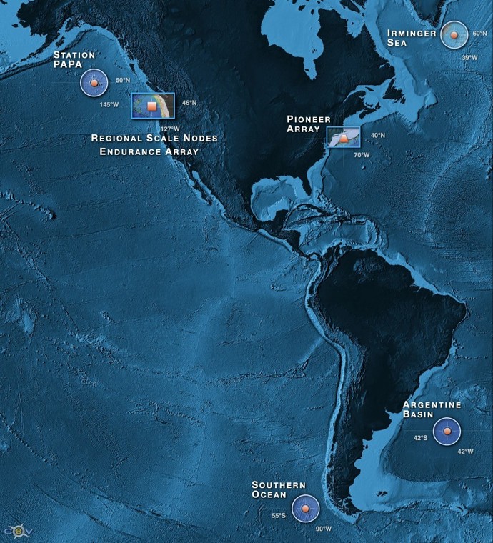
Regional, Coastal, Global Studies: Spanning the Western Hemisphere
The Ocean Observatories Initiative (OOI), a project funded by the National Science Foundation, is a networked infrastructure of science-driven sensor systems to measure the physical, chemical, geological, and biological variables in the ocean and seafloor. Through the Cyberinfrastructure, the OOI is an integrated system collecting and providing data on coastal, regional and global scales over the next ~25-30 years.
Major science themes of the OOI program include:
- Ocean - Atmosphere Exchange
- Climate Variability, Ocean Circulation, and Ecosystems
- Turbulent Mixing and Biophysical Interactions
- Coastal Ocean Dynamics and Ecosystems
- Fluid - Rock Interactions and the Sub-seafloor Biosphere
- Plate-scale Geodynamics
Regional Cabled Array: Cabled high power and bandwidth
The cabled high power (up to 10 kW) and bandwidth (10 Gb/s) component of the OOI is called the Cabled Array (past names include the Regional Scale Nodes and NEPTUNE). A network of 900 km of fiber optic cables, and 33,000 meters of extension cables spans the Juan de Fuca tectonic plate, and includes cabled arrays of sensors on the seafloor and throughout the water column. Implementation of the Cabled Array is led by the University of Washington (UW).
Coastal: Cabled and uncabled moorings
Coastal studies in the Pacific will be facilitated by an array of cabled and uncabled moorings across the continental shelf off Newport, Oregon, and Grays Harbor, Washington. Implementation of the uncabled Coastal Scale Nodes is overseen by Woods Hole Oceanographic Institution and its partner, Oregon State University.
Global: Moorings at high latitudes
Global studies will be facilitated by moorings at four sites, one each in the Pacific near the Queen Charlotte Islands, the Southern Ocean near Chile, the Atlantic near Greenland, and the Atlantic off Argentina. Implementation of the Global Scale Nodes is overseen by Woods Hole Oceanographic Institution and Scripps Institution of Oceanography.
Unprecedented opportunities: streaming via the Internet
High-bandwidth data, high-definition video and digital still imagery are being streamed live from the cabled observatory via the Internet to researchers, educators, and the public. Data from uncabled moorings will be sent to satellites and then to the internet. The Cyberinfrastructure component of the OOI is facilitating use, storage, and visualization of the myriad data sets. Implementation of the cyberinfrastructure architecture is led by the University of Rutgers.
In concert this transformative infrastructure with real-time and adaptive capabilities is providing unprecedented opportunities for scientists, educators, and the public to participate in cutting-edge oceanography.
The Ocean Observatories Initiative is managed and coordinated by the OOI Project Office at the Consortium for Ocean Leadership in Washington, D.C, and is responsible for construction and initial operations of the OOI network. Four major Implementing Organizations are responsible for construction and development of the overall program. Woods Hole Oceanographic Institution and Oregon State University are responsible for the uncabled coastal and global moorings and their autonomous vehicles. The University of Washington is responsible for cabled seafloor systems and instrumented moorings with wire crawlers and winched profilers.
