Related Stories
Student Blogs V14
As part of their participation in the VISIONS '14 cruises, students in the Univer ...
Related Images and Videos : View All
Friedrich Knuth's Blog
Sunday, July 27, 2014
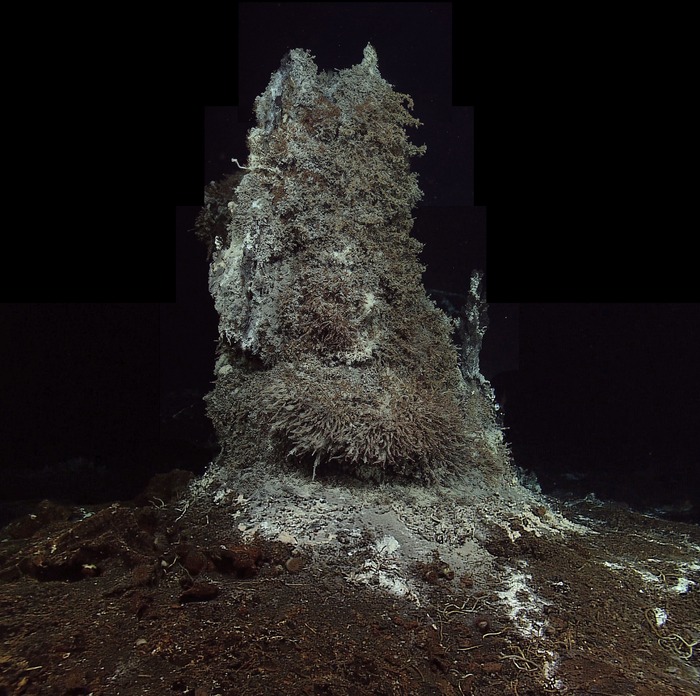

The ROV ROPOS powers up the RSN-OOI camera for the first time at the hydrothermal chimney called Mushroom. This image is from ROPOS with the vehicle lights off, and only the RSN-OOI HD camera providing illumination of the chimney while collecting the first video imagery from the seafloor, which was then streamed live over the Internet. Photo credit: NSF-OOI/UW/CSSF.

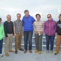
Friedrich Knuth and Jet Leo take a selfy on the bow, where they conduct their evening workout. Photo credit: Friedrich Knuth, College of Charleston, V14.
27 July 2014
Tonight’s dive was fascinating. It was my first time seeing the ASHES hydrothermal vent field. Very impressive. We were primarily deploying instruments around Mushroom and Inferno, two vents in the system. I guess the field got its name because the cracked basalt floor looks like it has ashes sprinkled throughout. We inspected last year’s HD camera, pointed right at Mushroom, and replaced a thermistor array built by Giora. Every operation that seams so simple on land is a delicate activity under water. The vents were beautiful, but I think my favorite so far were seeing El Gordo and Escargot.
26 July 2014
Seas have been calm so we were finally able to deploy ROCLS and lay the cable RS03W9 at Central Caldera. It was quite the operation, since we had to lower the 7,500 lbs ROCLS cable spool down using the winch of the ship on one side, while deploying ROPOS on the other. Once everything was on the bottom of the seafloor we picked up ROCLS with the ROV and were able to lay the cable. Sounds simple enough, but this all was a 21 hour operation. Finally done!
25 July 2014
Leo and I have started working out together on the bow of the ship. It has been nice since we have usually been facing west at sun set. Working out on the ship is a great way to release some energy, schedule the day and stay fit. Three weeks is a long time at sea and can be difficult not to be able to walk more than 20 feet in one direction.
The food on board has been really excellent. Sarah, our cook, really knows what’s good. Sambal Olek, Marmite, Anchovies, Mint Jelly and many other embellishments have been readily available to garnish the fantastic dishes coming out of that kitchen. ON top of it, she just put up three different hammocks on the bow. The lady definitely knows how to keep morale up. I also discovered that the water fountain right in the middle of the mess. It spits out super cold and delicious tasting water, much better than that coupled with the ice machine.
23 July 2014
I am simply in awe of this project and the scientific caliber on board. Orest, Giora, Skip, Deb and John and so many more world class scientists and engineers are all working on this project. It is amazing to hear them speak and have the chance to look at the world through their eyes.
Giora just gave his talk on Lost City today. Seems like it stirred up a lot of public interest, not only because of the captivating name “Lost City” but also because some people were under the impression that his worked somehow proves the viability of abiotic hydrocarbon production on a renewable scale. In no way was this the case, as both geologic time and scale of production are still the limiting factors, just as in biotic hydrocarbon production. Regards, the fact that hydrocarbon chains are produced under these conditions is fascinating. Charles also mentioned some of the work being done at Lost City to uncover the origins of life (Martin et al. 2008).
21 July 2014
Last night’s dive was awesome. We came in just as they were leveling the seismometer. To do this they laid a disk with a marble suspended in liquid inside it and then leveled the platform of the seismometer until the marble was within a 2 degree angle. This whole process made me think of my students in the Intro Geology Lab huffing and puffing at leveling a tripod on the street while doing elevation profile surveys. Seeing ROPOS do this at 2,500 meters depth made me smile. I will definitely get a clip of the video so we can show it to the intro students before they go out in the field. Just to give them a little perspective.
After leveling the seismometer we proceeded to survey two hydrothermal vents, El Gordo and Escargot. Escargot really has a funny shape and looks like a snail. El Gordo on the other hand is fat and plump, which lends itself to placing the mass spec at its base. Orest has been working non stop on preparing the mass spec so that it can be delivered to the seafloor.
19 July 2014
It has been a while since I have written a blog entry so I am switching up the format to sum up thoughts, impressions and highlights from the past few days.
Last night during my shift from 12:00 to 04:00 am we discovered a massive sea cucumber, which seems to be some type of sea pig. “King of the sea pigs!” is what we affectionately called it. There have been an unusual amount of sea pigs distributed across the seafloor. Perhaps it is spawning season for them? They are all facing one direction, which is peculiar and interesting. Sometimes it feels like they are all staring at ROPOS which is kind of funny. My guess is that there is something in the current this time of year and that they may in fact be spawning.
Between the king of the sea pigs and the flying cucumber, which some insist is a nudibranch, I am rather surprised at the diversity these creatures are showing. Leslie Sautter mentioned that sea cucumbers are Holothurian Echinoderms, and often have pentameral symmetry, which means they can be devided lengthwise into 5 symmetrical sections. Neither the sea pig or flying sea cucumber have this characteristic, so they are unusual Holothurians. I am not a taxonomist so please tweet your opinion if you have one. There certainly is room for a project to study and classify these and other creatures. The fact that so many of the species down here don’t have a common name or are even entirely unclassified is rather exciting. I guess the same holds true for insects in the jungles of the world, but in my opinion the creatures of the depth are much more endearing. It’s like Babe the pig, except fluorescent blue and on the seafloor. Both like playing in the mud though, so clearly it is a pig.
In any case, scientific discussion takes center stage with students and faculty on board, but day to day operations are heavily focused on the engineering aspects of the project. Like I mentioned in an earlier post, designing the best method for quality data collection is one of the main challenges any scientist faces, especially in this kind of environment. In fact, a strong understanding of engineering and technology is a must for any scientist interested in focusing their work on, in and around extreme environments, such as the depths of the ocean and far reaches of outer space. It is not surprising to me that many scientists, especially geologists and microbial biologists, traverse the field of deep ocean oceanography and extraterrestrial exploration. In my humble opinion I feel like NASA’s budget should fund and support some of the exploration happening in the most extreme environments of our own planet, specifically the deep ocean. What better training facility can there be? Perhaps there should be a new interdisciplinary research funding pool focused on science technology and engineering in extreme environments. The Extreme Environments Exploratory Institute EEEI, funded 2:1 by NASA and NOAA budgets.
Finally, I would like to mentioned the idea of creating something like Google’s Street View, except of the OOI. Imagine a map on which you can place a little ROV, instead of the street view mannequin, and then fly from node to node, along cables and up close to any sensor to see first-hand what the network looks like in real life. Then, just like you can enter restaurants and other businesses with street view, you would have the ability to enter the sensor. What does the sensor look like on the inside? What do its outputs look like? Where did it come from and how did it have to be modified for this extreme environment? The possibilities for interactive learning are endless. Google has partnered with the Catlin Seaview Survey to document shallow water coral reef ecosystems and place them within a framework that allows anyone to explore the coral reef the same way they would walk down a street in Google Maps Street View. Street View for the ocean is a fantastic and interactive way to bring the ocean to life. I envision the same type of interactive platform for the OOI, except even better. I know that the Catlin survey is beginning to document mesophotic and deep sea coral environments, so the capability to integrate ROV camera footage into Google’s framework certainly already exists. Since both Catlin (Google) and OOI are very well funded, OOI footage is abundant and it is merely a matter of software engineering at this point, it seems to me that enabling this vision is but a matter of setting it in motion at the highest level of decision making. Of course this could be conceived as a Master’s thesis project for a clever young software engineer, however, not only does Google have it down when it comes to combining imagery and geospatial information, they also seem like an obvious partner in spreading the message about the importance of the ocean to the rest of the world. Did anyone say Schmidt Ocean Institute? R/V Falkor? Google Fiber???
15 July 2014
10:30 Workout.
11:00 We are cutting cable on the seafloor and tracing last years steps to recover the terminal ends of the dysfunctional cable. Those connectors along are worth 30,000 USD!!!
11:30 Excellent shrimp tacos for lunch.
14:00 Presentation by John Wonderly. John is a K through 12 teacher taking initiative to build a platform for his school to become a STEM school. OOI is a fantastic project to expose his students to and has the potential to position his program as a “lighthouse” exemplary program within the State of Washington. After the meeting I introduced John to the Augmented Reality Sandbox developed at UC Davis. It is a fantastic tool for teaching earth system science to K-12 and even at the introductory college level. It was primarily developed to explore watershed system dynamics and topography but has since been expanded to model volcanoes and lava flow. John was very excited.
21:00 Brief introduction to COVE and how our cable routes are planned. The software is visually very appealing, but there seems to be a steep learning curve and little support. It is open source however, so it may be worth the while to get familiar with.
00:00 Start of shift. ROV is on board. Winds are picking up so we will have to see when we can deploy ROPOS again. Katie shared a massive mosaic raster file that she would like to classify into different bottom types. Ideally, we can run an unsupervised classification on all the rasters to gain insight into percent bottom cover by microbial mats. This could be great information for the biology team and potentially be developed into a GIS exercise for students back at CofC.
14 July 2014
6:00 Lecture on OOI history, infrastructure, sensors and future vision by John. Interesting notes on the timeline of completion. This project was all planned to begin in 2001, but construction was delayed by the war. Canada has completed its network. The US started in 2009. Hopefully we will have the initial infrastructure completed by 2015, but the vision extends far beyond that towards wiring the entire subduction zone.
7:15 Workout followed by breakfast. Roommate Don and a few others are struggling with sea sickness. Camomile tea, ginger slices, bottled water, saltines, Dramamine… all no use. Kid can’t keep it down but is somehow all smiles still! What a spirit!
8:30 Working on definitions project. Learning a lot about physical and chemical oceanography on the fly! Reading papers online about Surfactants, Dimethyl Sulfide Flux, Mesoscale Eddies… who needs textbooks these days!
13:00 Introduction to the Integrated Real Time Logging System (IRLS). My shift will be 00:00 - 04:00. Our goal is to log HD video and camera footage from the ROV ROPOS. It is quite the machine and I am really looking forward to seeing it in action!
19:00 Meeting with John, Deb, Leslie and co. John had most of the engineering team step into our circle, introduce themselves and what they do. I am really enjoying this informal way of learning on the fly. It is casual but everyone is present and engaged. We have a great group of students and the questions are always abundant. The engineers seem to be a lively and happy bunch as well. Some of the challenges they face are mind boggling. For example, to think that we will be running mass spectrometry at 2000 meters below the seafloor and collecting the data in real time is simply amazing, considering what a mass spec looked like just 15 years ago. Or even a seemingly simple task such as tying a knot so that it may be easily untied by the robot at 2000 meters depth becomes a particular challenge.
03:00 We are on site and deploying the ROV ROPOS. Photo logging is going smoothly. A small squid latches on as we descend.
13 July 2014
11:00 Initial Science Meeting. All science crew present. Notable overview of AB, ABC and D fire extinguishers. Otherwise common sense tips on safety and procedures.
12:00 Departure from the dock. World Cup final begins. Germany vs. Argentina.
14:15 Fire Drill. Gumby suit comfortable as usual.
15:00 Deutschland wird Weltmeister!!!
16:00 First meeting to go over purpose of science projects conducted by students. Projects include: a) Life on a research vessel. b) Sensors, instruments and infrastructure. c) Biology at depth.
17:00 Delicious ribs for dinner. Conversation with Dana Manalang about procurement, constellation and the big systems architecture behind fusing all technical components of the observatory. “You can’t just go buy off the shelf solutions.” A lot had to be conceived and custom made to fit the specific needs of the project or research questions being asked. To me, this really captures part of what it means to be a scientist. Finding solutions to unknown challenges and often ambiguous situations. In a sense it reminds me of the interview with Johnny Ive in the movie Objectified. A memorable point he makes is that as a designer he often spends more time designing the fixtures and machines to create products, rather than the products themselves. In the same way, as scientists, we must often spend a lot of time and thought on how to effectively create and use instruments to gather good or better data, rather than just analyzing the data and answering the underlying research questions. The journey is long and complex but great science is never a path more or less trodden upon; it is always the path no one has ever traveled before.
19:00 Final meeting of the day with John. Presentation on art, music, poetry and cultural thought with the ocean as its muse. Historically, we have always been captivated by the vast expansiveness of the ocean. Has the advent of cheap air travel slowly removed the mystery of what lies beyond the liquid horizon? Is the public losing its fascination because the wonders that happen beneath the surface are largely out of sight - out of mind, as we skip from continent to continent? Even if we overcome the challenges of being out of sight - out of mind, how can we elevate the impending telepresence to something more than just another channel on TV or the internet? Will the public imagination recapture the wonder that is our ocean? The source of life on Earth, the fundamental food support system for our planet? This battle cannot be won by competing with the entertainment industry. It will be won by giving educators the tools to capture the imagination and hearts of students at an early age.
