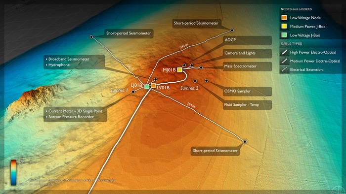
Location: 44.6ºN 125.1ºW Water Depth: 780-771 meters Primary Node: PN1B
The Southern Hydrate Ridge study site (~10 km north of Primary Node PN1B) hosts abundant deposits of frozen methane (methane hydrates) that are buried beneath the seafloor. The deposits vent methane-rich fluids and bubbles that escape through seeps on the ocean bottom. Dense and fascinating communities of microbes and animals are fueled by these escaping gases. Methane is a powerful greenhouse gas and, therefore, quantifying the flux of methane from the seafloor into the hydrosphere is critical to understanding carbon-cycle dynamics and the impacts of global warming on methane release.
Southern Hydrate Ridge is an important observatory site to define the temporal evolution of methane hydrate systems in response to seismic events. It is also an important area to quantify material fluxes from the seafloor and the impacts of methane release on overlying ocean chemistry. It provides an excellent opportunity to understand biogeochemical coupling associated with gas hydrate formation and destruction.
During VISIONS '14, Leg 4 is scheduled to deploy a junction box and a series of instruments at Southern Hydrate Ridge. The initial plan is for ROPOS to perform a site survey to ensure that the venting is still occurring at the main installation site. After the survey, a series of operations are scheduled, including the installation of 3 extension cables using ROCLES and the deployment of broadband and short-period seismometers. EM302 surveys are also planned above Southern Hydrate Ridge to image bubble plumes, and during ROV downtime it is anticipated that there will be CTD casts to collect water samples to validate instruments.


