Slope Base V18
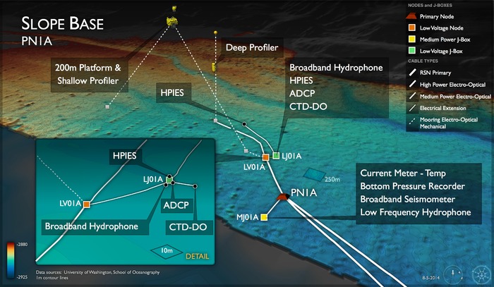

Bathymetric map showing OOI core infrastructure as installed in 2017 at the Slope Base site. Credit: M. Elend, University of Washington.

This strange fish, Genioliparis ferox (Stein), was first described in 1978 from a single specimen and never seen afterwards. It was imaged at 2901 m at the Slope Base Site during ROPOS Dive R1757. G. ferox is a ferocious mid-water predator, with many sharp teeth.
Photo Credit: NSF-OOI/UW/CSSF; Dive R1757; V14
Water Depth: 2906-2909 meters
The Slope Base study site (Primary Node PN1A) is located near the foot of the continental slope about 60 miles (125 km) west of Newport, Oregon. This site is just west of the Cascadia Subduction Zone, where mega-earthquakes have occurred, producing tsunamis that impacted both NW coastal commmunities, as well as those along the east coast of Japan. The last magnitude 9 earthquake occurred in 1700. Just to the east, is the steep, continental slope that may result in strong topographic forcing effects on ocean currents.
The coastal region of the Pacific Northwest is a classic wind-driven upwelling system where nutrient-rich deep waters rise to replace warmer surface waters. The result is a large increase in marine productivity that ranges from phytoplankton to fish to marine mammals. Near bottom fauna are periodically negatively impacted by flow of deep waters with very low oxygen concentrations (hypoxia events), and upwelling of corrosive, acidified waters onto the continental shelf.
Coupled with other Cabled and Endurance Array installations off the central Oregon coast, the Slope Base site provides a wide variety of opportunities for seismic and coastal studies, including cross-shelf and along-shelf variability.
