Related Images and Videos
Southern Hydrate Ridge Study Site (PN1B)

A strong plume of methane-rich bubbles issue from the seafloor at the Summit of Southern Hydrate Ridge. This area collapsed sometime between 2010 and 2011, probably due to methane release from the subsurface. VISIONS '13, Leg 4
Photo credit: NSF-OOI/UW/CSSF

This instrument, nicknamed a "Mosquito" was deployed in 2011 at the summit of Southern Hydrate Ridge. It will be recovered during VISIONS'13 and replaced by two additional mosquitos.
Location: 44.6ºN 125.1ºW Water Depth: 780-771 meters
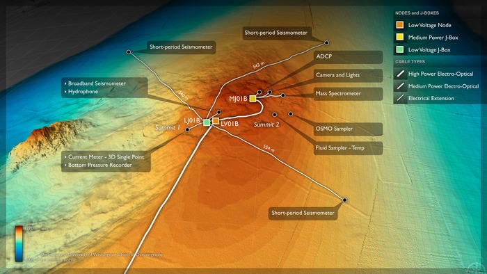
The Southern Hydrate Ridge study site (~10 km north of Primary Node PN1B) hosts abundant deposits of frozen methane (methane hydrates) that are buried beneath the seafloor. The deposits vent methane-rich fluids and bubbles that escape through seeps on the ocean bottom. Dense and fascinating communities of microbes and animals are fueled by these escaping gases. Methane is a powerful greenhouse gas and, therefore, quantifying the flux of methane from the seafloor into the hydrosphere is critical to understanding carbon-cycle dynamics and the impacts of global warming on methane release.
The chemical, biological, and geophysical sensors that will be installed at this site in 2014 will allow the first long-term, detailed investigation of such questions as the effects of seismic events on the release of hydrates and methane gas into the overlying ocean, and the changes in microbial and animal communities over time. In situ cameras, flow sensors, and a mass spectrometer will allow investigation of how changes in fluid flow and chemistry impact the biological communities that thrive in this environment.
During the VISIONS'13 Expedition, two uncabled benthic flow meters were installed at Southern Hydrate Ridge, as well as a caisson for follow-on deployment of a braodband seismometer
Instruments to be installed at this site include in 2014:
