Related Images and Videos : View All
Related PDF's
Related Stories

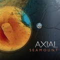
Mapping Axial Seamoun
UW undergraduate student Brendan Philip and graduate student Alden Denny describ ...
Mapping Axial Seamoun
A suite of three papers published this week in Nature Geoscience address the 2011 ...
Axial Science Worksho
A science workshop on the RSN cabled observatory at Axial Seamount was held in Oc ...
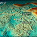
Axial Base (PN3A)
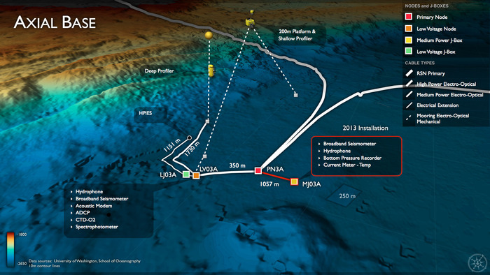
Description of instruments that are installed at the base of Axial Seamount (PN3A)

Since the late summer, 2015, each of the three cabled Shallow Profiler Mooring winched science pods have made >7000 cycles from 600 ft water depth to just beneath the oceans' surface. Real-time command and control of these systems through the Internet provides response capabilites such that the science pods can be stopped to take key measurements in response to events that include the passing over of biologically-rich thin layers. Credit: University of Washington, NSF-OOI/ROPOS, V15.
In contrast to the margin setting of PN1A, the mooring at Axial Seamount is far from the continental shelft (>350 km) and hence represents an open-ocean or pelagic site in the continuum of observing scales represented in the OOI's cabled system. Here, large-scale currents including the North Pacific Current, the subpolar gyre and the northern end of the California Current interact. These currents transport heat, salt, oxygen, and biota, all of which are crucial to the region's ecosystem. However, their variability arises from forcing as varied as tides and winds to interannual (El Niño) to decadal (Pacific Decadal Oscillation) timescales. Examples of relevant science questions represented in the OOI Science Requirements include: 1) How, and how strongly do tidal currents break down into turbulence, and what are the feedbacks on the large scale current system? Internal tides are ubiquitos vertical motions formed by tidal currents flowing past bottom features such as Axial Seamount and the base of continental margins with steep topography; 2) What is the impact of long- and short-term forcing changes on the structure and transports of the large-scale current system? What are their effects on the ecosystem? Together with the mooring Ocean Station Papa, these processes can be studied with observing platforms in the water column at these two sites.
Location: 46.1082ºN 129.6182ºW Water Depth: 2650-2654 meters
Infrastructure:
- 1 Low-Voltage Node
- 1 Medium-Power Junction Box
- 1 Low-Power Junction Box
- 1 Deep Profiler Mooring
- 1 Shallow Profiler Mooring and 200m Platform
- Instruments (pdf above)
