Related Images and Videos : View All
Endurance Array Newport Line

During dive R1674, the instrumented shallow winched profiler system was installed onto the platform at 197 m water depth on the tw-legged mooring. This marks a first of the OOI program. Photo credit: NSF-OOI/UW/CSSF; Dive R1764; V14.

The Benthic Experiment Package (BEP) deployed at the Endurance Offshore site (600 meters depth) and plugged into low-voltage node LV01C.
Photo Credit: NSF-OOI/UW/CSSF, Dive 1745, V14
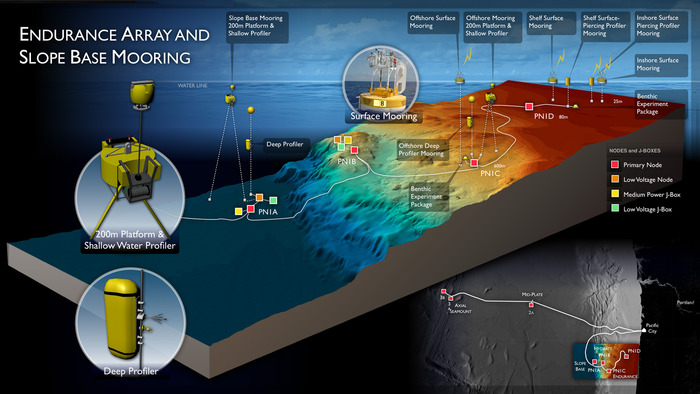
The Endurance Array is a multi-scale array utilizing fixed and mobile assets to observe crossshelf and along-shelf variability in the coastal upwelling region off the Oregon and Washington coasts, while at the same time providing an extended spatial footprint that encompasses a prototypical eastern boundary current regime and overlaps the OOI Cabled Array infrastructure. The Endurance Offshore* and Endurance Inshore** sites are shared between the UW Cabled Array and Oregon State University that oversees uncabled infrastructure at these sites. This integrated infrastructure bridges processes from the coastal zone (OOI Coastal/Global Scale Nodes) through their transition into the ocean basin interior (OOI Cabled Array), and outward to the pelagic North Pacific (Station Papa). To provide synoptic, multi-scale observations of the eastern boundary current regime, two cross-shelf moored array lines, each with three instrumented sites, are supplemented by six gliders patrolling the coastal region (operated by Oregon State University). The Endurance Array is composed of two lines of moorings, the Newport Line off the Oregon coast and the Grays Harbor Line off the Washington coast.
Endurance Array Newport Line Technical Approach
The Endurance Array Newport Line includes three fixed sites that are aligned perpendicular to isobaths and that span ocean regimes from offshore (600 m) to mid-shelf (80 m) and inshore (25 m). The offshore and shelf sites combine fully-instrumented surface platforms with cabled profilers and benthic boundary layer sensors. The inshore site combines a wave-hardened surface platform electromechanically linked to benthic boundary layer sensors and a stand-alone surface-piercing profiler. The three environments are linked physically, biologically, and geologically, yet represent distinctly different processes. As an example, wave forcing is especially important at the 25 m site, while local and remote wind forcing are dominant at the mid-shelf site. Slope currents and offshore mesoscale variability is important at the slope site.
The most transformative design element of the offshore and shelf sites includes cabled infrastructure that integrates the OOI Endurance Array infrastructure with the Cabled Array through Primary Nodes PN1C and PN1D. This internal OOI partnership extends the reach and capability of the OOI regional cabled infrastructure into the coastal environment, while simultaneously providing the transformative high-power, high-bandwidth capabilities to the OOI coastal infrastructure.
The cabled infrastructure supports an extensive suite of core sensors deployed on Deep and Shallow Profiler moorings at the Oregon Offshore site and at the Slopr Base Site, as well as benthic nodes. Equally important, the cable also provides outstanding access for the science user community, enabling experiments requiring high-power, high-bandwidth sensors. Uncabled surface moorings are now installed at the Oregon Offshore (~600 m), Shelf (~80 m) and nearshore sites (25 m) sites. These moorings will provide continuous meteorological and near-surface oceanographic measurements.
Further details about the Endurance Array may be found here.
*Endurance Offshore Study Site
Location: 44.2ºN 124.6ºW Water Depth: 585 to 615 meters
The Oregon Offshore Study Site at RSN Primary Node PN1C hosts two cabled moorings and and one uncabled mooring, as well as a seafloor Benthic Experiment Package (BEP). Shared with the Cabled Array, this Endurance Array site is part of two cross-margin instrumented arrays along the Oregon (west of Newport) and Washington margins (west of Grays Harbor). The Newport Endurance Line consists of both cabled and uncabled moorings and seafloor infrastructure, while the Grays Harbor site consists of uncabled moorings. These sites are designed to examine biogeochemical and physcial oceanographic processes within these highly productive coastal environments. The ecosystems are significantly impacted by wind-driven upwelling of nutrient-rich currents, and at times by hypoxia events. In addition to the moorings and seafloor instruments, a series of autonomous gliders will travel from the near shore to deep waters and will provide three-dimensional measurements of ocean chemistry, biology, and currents.
In 2014, a Benthic Experiment Package was installed at ~585 meters water depth and houses the following instruments:
Broadband Hydrophone
Acoustic Doppler Current Profiler (ADCP)
Conductivity-Temperature-Depth (CTD) and Dissolved Oxygen Sensors
Turbulent-Flow Current Meter (VEL3D)
pH and CO2 Sensors
Optical Attenuation Sensor
** Endurance Inshore Study Site
Location: 44°38.238ºN 124°18.336ºW Water Depth: 80 meters
The Oregon Inshore Site, at a water depth of 80 m, is the shallowest cabled site along the Oregon Endurance Array. In concert,these mooring lines provide synoptic, multi-scale observations of the eastern boundary current regime. The Oregon and Washington Lines are both affected by wind-driven upwelling and downwelling, but shelf stratification and upper-ocean properties are influenced differently at each location by the Columbia River outflow. Observations at both locations will allow for a greater understanding of coastal ocean ecosystem responses to climate variability.
