Related Images and Videos
Related Stories
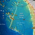
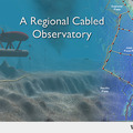
The Cabled Component
The fiber-optic cables of the Cabled Array, the cabled component of the NSF Ocea ...
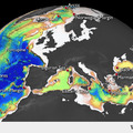
EMSO-ESONET
European Multidisciplinary Seafloor Observation (EMSO) is the European large-scal ...
Observatories
We must understand the oceans to optimize the benefits and mitigate the hazards o ...
The NEPTUNE Concept:
High Power and High Bandwidth in the Oceans: The concept of a regional cabled oc ...
NSF Ocean Observatories Initiative
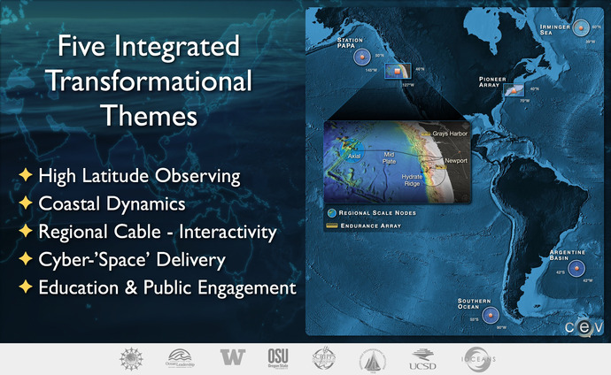
There are 47 classes of sensors making up the 759 total sensors in the OOI program, spread across the Northern and Southern Hemispheres in the Atlantic and Pacific Oceans.
Regional, Coastal, Global Studies
The National Science Foundation's Ocean Observatories Initiative (NSF-OOI) has installed a network of instruments, undersea cables, and instrumented moorings that spans the Western Hemisphere. The OOI is a fully integrated system and that measures physical, chemical, geological, and biological phenomena in carefully selected key coastal, regional, and global areas.
Greater knowledge of the ocean’s interrelated systems is vital for increased understanding of effects on biodiversity, global warming, ocean and coastal ecosystems, environmental health and climate. The OOI, through the Data Portal is now placing real-time ocean data in the hands of a vast user community of oceanographers, scientists and researchers, educators and the public.
The OOI Program is managed and coordinated by the OOI Project Office at the Consortium for Ocean Leadership, in Washington, D.C., which was responsible for construction and is now coordinating initial operations of the OOI network. Three Marine Implementing Organizations (MIO's) are responsible for construction and operations of infrastructure on the seafloor and throughout the water column.The University of Washington is responsible for the cabled seafloor networks and moorings that stream live data to shore 24/7. Woods Hole Oceanographic Institution and Oregon State University are responsible for coastal and global moorings and their autonomous vehicles. The fourth implementing organization, led by Rutgers University is responsible for the cyberinfrastructure/data management.
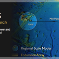
Regional: Cabled high power and bandwidth
The cabled high power (8 kW) and bandwidth (10 Gbs) component of the NSF OOI is called the Cabled Array, previously known as Regional Scale Nodes and NEPTUNE. This network spans the Juan de Fuca tectonic plate, and includes cabled arrays of sensors on the seafloor and throughout the water column. Implementation and operation of the OOI Cabled Array is led by the University of Washington, which includes the School of Oceanography, College of the Environment and Applied Physics Laboratory. The Cabled Array is highly expandable with power up to 200 kW and bandwidth up to 240 Gb/s.
Coastal: Cabled and uncabled moorings
Coastal studies in the Pacific are facilitated by an array of cabled and uncabled moorings across the continental shelf off Newport, Oregon, and Grays Harbor, Washington. Implementation of the east and west coat arrays of Coastal Scale Nodes is overseen by Woods Hole Oceanographic Institution and its partner, Oregon State University for uncabled infrastructure. The University of Washington oversees cabled infrastructure along the Oregon Endurance Array.
Global: Moorings at high latitudes
Global studies will be facilitated by moorings at four sites, one each in the Pacific near the Queen Charlotte Islands, the Southern Ocean near Chile, the Atlantic near Greenland, and the Atlantic off Argentina. Implementation of the Global Scale Nodes is overseen by Woods Hole Oceanographic Institution and Oregon State University.
Unprecedented opportunities: streaming via the Internet
High-bandwidth data, high-definition video and digital still imagery since 2014 have been streamed live from the cabled observatory via the Internet to researchers, educators, and the public. Some data from uncabled moorings is being sent to satellites and then to the Internet: the majority of data are recovered once instruments are recovered on the moorings. The Cyberinfrastructure component of the OOI is facilitating use, storage, and visualization of the myriad data sets. Implementation of the cyberinfrastructure is lead by Rutgers University.
In concert this transformative infrastructure with real-time and adaptive capabilities will provide unprecedented opportunities for scientists, educators, and the public to participate in cutting-edge oceanography. The Education and Public Engagement component of the OOI will help facilitate use of this infrastructure by a diverse national and international community.
