Related Images and Videos
Science Users
Overview
The Regional Scale Nodes component of the National Science Foundation's Ocean Observatories Initiative provides unprecedented power (10 kV) and bandwidth (10 Gb/s) to scientific sensor arrays on the seafloor and throughout the water column using instrumented moorings.
Scientists interested in using the RSN will find information here on infrastructure and study site locations based on the Final Network Design (FND), which was released as a public document in January 2010. The FND is based on elements of the Preliminary Network Design, on criteria outlined in the OOI Science Requirements, eleven RSN-specific requirements documents, and on five technical specifications documents. The FND also incorporates the findings of two trade-off studies completed by the University of Washington, the RSN Implementing Organization, to investigate optimal configuration of the cabled backbone infrastructure or Primary Infrastructure, and shore station location, and an additional White Paper describing the Secondary Infrastructure. Links to these documents may be found within each section of this website.
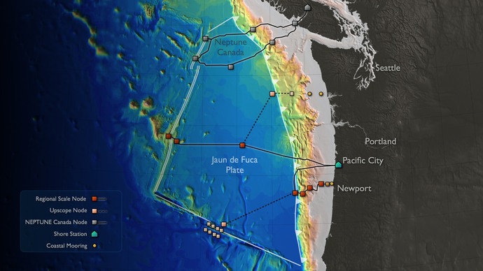
The RSN utilizes a Star configuration with one shore station and seven Primary Nodes with the following designations: Node 1A (Hydrate Ridge) and Node 1B (Southern Hydrate Ridge); Node 3A (Axial Seamount) and Node 3B (Eastern Caldera); and Node 5A (Mid-Plate). The Hydrate Ridge infrastructure also includes two additional Primary Nodes, Node 1C and Node 1D, which comprise part of the Coastal Scale Nodes Endurance Oregon Line extension: Node 1C is shared by RSN and CGSN. The shore station located in Pacific City, Oregon includes two cable landings serving Hydrate Ridge, Axial Seamount, and the Mid-Plate site. The Primary Nodes convert the high cable line power voltage (10 kV) to a lower (375 V) level and distribute it to Science Ports along with communications and timing signals. A 5 km cable will extend from the mid-plate site for future expansion.
