- Visions18
- Visions17
- Visions16
- Visions15
- Visions14
- Construction
- Visions13
- Visions12
- Visions11
-
Enlighten
- As Enlighten '10 Ends
- Exploring an Active Caldera
- Life in the Extreme
- Dive J2-516
- Transforming the ROV Jason
- Weather: Sunday August 15, 2010 ...
- International District to ASHES ...
- A Day Full of Vents and Sunshin ...
- Students at Sea
- Captain's Weather Report
- Weathering a Bit of a Blow
- Details at ASHES
- First Jason Dive at Axial Seamo ...
- David's Spheres
- Newport to Axial Volcano
- Port Call, Newport, Oregon
- Final Science Day Leg 1
- Nice Weather
- Finding a Passion
- Meter-Scale Imaging
- Bubbles from the Seafloor
- Documenting Seep Sites
- Social and Scientific
- Nested Surveys
- Kinship Aboard the Thompson
- Exploring Gary's Bad Hang with ...
August 2010
July 2010

Related Images and Videos
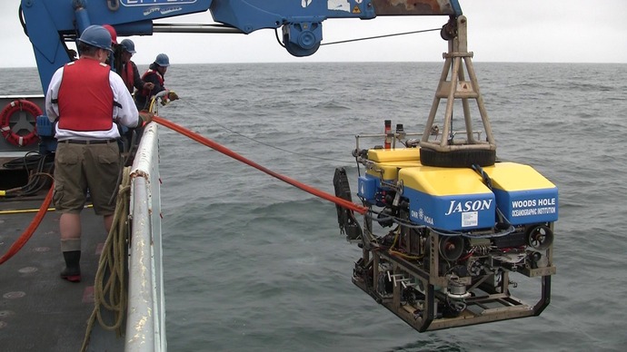
First Jason Lowering - Engineering Dive J2-506
Wednesday, July 28, 2010
Diving to 925 m in Grays Canyon

Screen shot of the CARIS program used for editing and visualizing the EM300 sonar data for bathymetric mapping.
Today is filled with anticipation of the first Jason dive. The goal of the engineering dive is to test multiple sensors and functions of the ROV. The test will be completed in ~ 925 m (3035 feet) water in Grays Canyon. Specific sensors that will be checked out include the RESON sonar system used for obtaining < 1 m resolution maps of the seafloor, a high-definition camera, and a down-looking camera for photomosaicking of the seafloor. In addition, the pilots and navigators will be rechecking the navigation obtained by the USBL system.
After a thorough deck check-out of Jason, the vehicle went into the water at ~1430 and descended to near the bottom. There is a very high abundance of particles in the water at 900 m in this area, resulting in poor visibility. Jason worked for several hours checking out all systems and returned to the surface at 2137.
Once Jason was secure on deck, an EM300 and 3.5 kHz survey was completed during the late-night hours running until 0900 on July 29. The survey was conducted over the proposed site for the Coastal Scale Nodes 500 m Grays Harbor mooring site of NSF's Ocean Observatories Initiative.